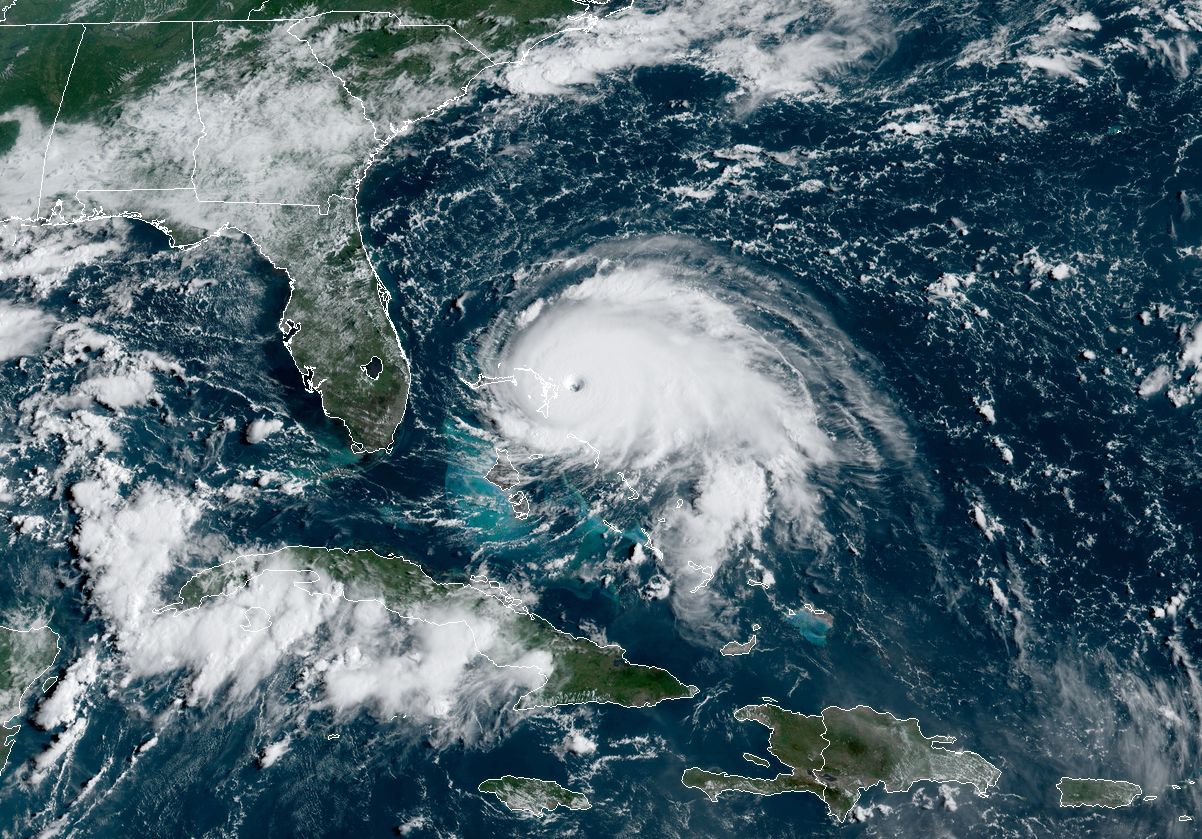
5pm ET Sunday Update: Hurricane Dorian continues to pound the northern Bahamas, and has strengthened a little bit further on Sunday. As of 5pm CT (21:00 UTC), Dorian has a central pressure of 910 millibars, and maximum winds of 185mph.
Such a maximum sustained wind speed places Dorian in very rare company when it comes to historical hurricane record in the Atlantic. Only Hurricane Allen, in 1980, recorded stronger winds in the Atlantic Ocean, Caribbean Sea, or Gulf of Mexico. Three other hurricanes have recorded winds as strong as Dorian—the 1935 Labor Day hurricane, Gilbert (1988), and Wilma (2005).
The overall forecast remains more or less the same. In a couple of days Dorian will approach the Florida peninsula. The most likely scenario is that Dorian remains offshore as it traces an arc up the Southeastern United States coast, but all scenarios remain on the table, including a Florida landfall.
Original post: Early on Sunday morning, Hurricane Dorian moved across some of the warmest waters in the Atlantic Ocean. The bathtub-like seas, combined with a relatively smooth atmosphere in Dorian's path, allowed the hurricane to intensify to 180mph, and attain Category-5 status on the Saffir-Simpson scale. Further strengthening is possible, as pressures were continuing to fall shortly before noon, Eastern.
The storm presents an immediate and extreme danger to the Abaco islands in the northern Bahamas, including the city of Freeport. In an update at 8:30am ET on Sunday, forecasters at the National Hurricane Center did not mince words, writing, "The eyewall of catastrophic Hurricane Dorian is currently reaching the Abaco Islands. This is a life-threatening situation. Residents there should take immediate shelter. Do not venture into the eye if it passes over your location."
The threats include: 200mph wind gusts, a storm surge 15 to 20 feet above normal levels, and prolonged, heavy rainfall. Additionally, the storm's very slow forward speed—only about 8mph to the west—means these conditions will affect the northern Bahamas for the next 24 to 36 hours. It will have a devastating effect over such a long period of time.
Dorian's forward motion has been slowing because a high pressure ridge to its north, which has been helping push it to the west, is weakening. This, in turn, will cause the storm to all but come to a stop, although some wobbles are possible that will affect its path over the next couple of days.
In a couple of days—early Tuesday perhaps?—a low pressure system now over the Great Lakes region will push further to the southeast and help provide better steering winds. This trough of low pressure, producing thunderstorms over parts of Illinois and Indiana on Sunday morning, will effectively pull Dorian northward.
The key for the mainland United States, of course, will be when this turn occurs. At present, most of the best global model forecast guidance brings the trough in soon enough to pull Dorian northward before it reaches the Florida coast, and keeps it just far enough off the coasts of Georgia and the Carolinas to avoid catastrophic implications. However, any aforementioned wobbles to the west during the next couple of days would could certainly change this forecast.
It is always difficult to forecast intensity changes in hurricanes, but in this case there appears to be little to slow Dorian down for the next couple of days. The storm has only light wind shear to contend with, and even as it churns up water from below during the next couple of days, the oceanic heat content is such that it won't be drawing up enough cold water to really cause much weakening.
The most likely pattern will be periodic eyewall replacement cycles, in which the center of the storm gradually loses some coherence, and its replaced by a new eyewall. However, these fluctuations will probably maintain the storm's overall intensity between Category 4 and Category 5 status, rather than providing a more substantial weakening.