The sheer scale of flooding in the wake of the powerful storm that battered the U.S. Southeast this past weekend has been revealed in images released by NASA.
The before-and-after shots—taken by NASA's Landsat 9 Earth observation satellite—capture the "swollen" rivers that followed the torrential rainfall.
This, according to the National Weather Service, saw many areas receive up to 6 inches of rainfall in just a 48-hour period.
In Tennessee, a state of emergency was declared by the local authorities after a levee broke near the small town of Rives, which has a population roughly 250, along the Obion river.
It has been estimated that some 60 percent of homes in the town have suffered water damage as a result of the flooding, with residents evacuated to shelters set up in local community centers and schools.
Some 10 miles to the southwest, a U.S. Geological Survey water gauge in the town of Obion logged water levels hitting 39.8 feet on February 18—4.8 feet above the threshold for a flood stage.
Drag slider
compare photos
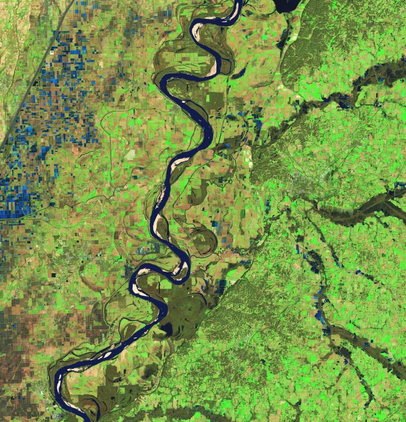
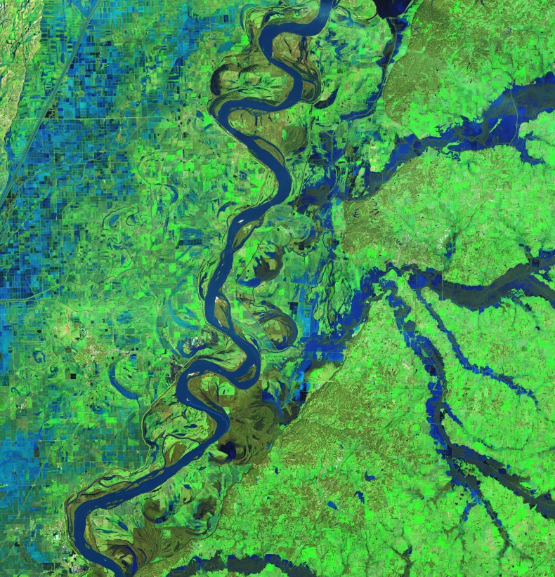
"The OLI-2 (Operational Land Imager-2) on Landsat 9 captured this false-color image of swollen rivers in western Tennessee on February 17, 2025; the image of the left shows the same area on January 24, 2025," NASA explained on its Earth Observatory website.
"The band combinations used in the images makes it easier to distinguish between water, land and vegetation."
The water in the post-flooding image appears a lighter shade of blue, the space agency explained, because it is rich in suspended sediments.
According to NASA, the water-covered fields that can be seen across Missouri in the images are rice fields.
Clarksville, Tennessee Fire Rescue members perform evacuations of flooded homes following the recent storm.Clarksville, Tennessee Fire Rescue members perform evacuations of flooded homes following the recent storm.Getty ImagesAs NASA notes, some of the most destructive flooding seen in the wake of this past weekend's storm actually occurred to the north of the region captured in these images.
Unfortunately, it explained, "clouds on February 17 prevented satellites from acquiring similar images of floodwater in that area."
Local residents could be set for fresh weather worries in the coming days, too, forecasters have warned—starting with a blast of cold air expected to enter the region from the north.
Meanwhile, a snowstorm coming from the west has the potential to deposit several inches of snow on many of the same areas that recently flooded.
Do you have a tip on a science story that Newsweek should be covering? Do you have a question about floods? Let us know via science@newsweek.com.


 "The OLI-2 (Operational Land Imager-2) on Landsat 9 captured this false-color image of swollen rivers in western Tennessee on February 17, 2025; the image of the left shows the same area on January 24, 2025," NASA explained on its Earth Observatory website.
"The band combinations used in the images makes it easier to distinguish between water, land and vegetation."
The water in the post-flooding image appears a lighter shade of blue, the space agency explained, because it is rich in suspended sediments.
According to NASA, the water-covered fields that can be seen across Missouri in the images are rice fields.
"The OLI-2 (Operational Land Imager-2) on Landsat 9 captured this false-color image of swollen rivers in western Tennessee on February 17, 2025; the image of the left shows the same area on January 24, 2025," NASA explained on its Earth Observatory website.
"The band combinations used in the images makes it easier to distinguish between water, land and vegetation."
The water in the post-flooding image appears a lighter shade of blue, the space agency explained, because it is rich in suspended sediments.
According to NASA, the water-covered fields that can be seen across Missouri in the images are rice fields.